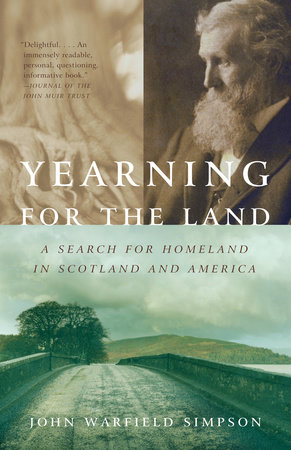
Yearning for the Land

A Search for Homeland in Scotland and America

Paperback
$14.00 US
On sale Oct 14, 2003 | 304 Pages | 9780375725470
A beautiful, meditative memoir mixed with travel and history, this unique book is the story of one American’s search for a deeper connection to the land. Drawn by a sense that he is missing a critical link to his home in suburban Ohio, John W. Simpson heads for rural Scotland, where he encounters his own family history as well as estate owners and tenant farmers who have centuries-long ties to their land.

As he travels, he meditates on the legacy of the great 19th century conservationist John Muir, who himself developed a complex love of the land when he immigrated from Scotland’s North Sea coast to the fields and forests of Wisconsin. As Simpson physically retraces Muir’s journey he wonders what sense of belonging Muir found on the frontier that modern America, with its strip malls and housing developments, has forgotten. A fascinating story of changing perceptions and values from the Old World to the New, Yearning for the Land shows us just how much roots matter—both in our own lives, and in the many ways time and history, landscape and community are tightly intertwined.


“Delightful. . . . An immensely readable, personal, questioning, informative book.” –Journal of the John Muir Trust

“An eloquent story of deep ties to true landscapes and the ways we bless and mark them.” –Ellen Meloy, author of Anthropology of Turquoise

“John Simpson has taken the concept of place and turned it inside out and upside down and backwards. A thorough, intriguing read.” —John Hanson Mitchell, author of Walking Towards Walden and Following the Sun

“A ruminative walk across the two regions that together created a man who helped create the modern United States.... With grace and tact [Simpson] introduces us to the people who live their now—their work, their dreams, their fears, their character.” —Preservation Magazine
Chapter 1

Prelude

"Once you have lived on the land, been a partner with its moods, secrets, and seasons, you cannot leave. The living land remembers, touching you in unguarded moments, saying, "I am here. You are part of me."

Ben Logan, The Land Remembers

[1]

February is dreich-cold, damp, and blustery-in the Lammermuir Hills and the coastal lowlands of East Lothian, Scotland, lending the land a gray skeletal starkness during the scarce daylight hours. I'm chilled to the bone. The rawness pervades everything, inside and out. From my promontory on Doon Hill, the northeastern face of the Lammermuirs, the inland sweep of the coastal plain lays a mile off and 500 feet below me. Dunbar sits at the nexus.

Oliver Cromwell, like all southern invaders of Scotland, knew the strategic importance of the place. The bleak, rolling moors atop the 1,400-foot-high shoulders of the Lammermuirs had blocked invading armies for centuries, forcing their advance up the coast to Dunbar, despite the Dunglass and Pease Deans that dissected the plain only miles away near the small village of Cockburnspath. There, a handful of soldiers could stymie an army trying to cross the deep, steep-faced rocky ravines. But the Scots were too busy arguing religion during the spring of 1650 to seize the advantage, allowing the English lord commander's New Model Army of 16,000 soldiers uncontested entry into the country's heartland. Preliminary skirmishes ensued from Edinburgh eastward into East Lothian as the Presbyterian Scots mobilized an army of 27,000 troops led by Lord Leslie and a committee of military officers and Covenant presbyters.

By late summer, Cromwell's fighting force had dwindled to less than 12,000. Months in the field, bad food, dysentery and other diseases, and battle casualties had taken a heavy toll. In response, he withdrew to Dunbar to use the crude local harbors for resupply and reinforcement. He also hoped to draw the Scots out into the open for a climactic confrontation. Leslie repositioned his main force of perhaps 22,000 Scots on the high ground where I stand. Like today, conditions then were deplorable-howling wind driving recurrent rain. But the hill offered a commanding view of Dunbar and its surrounding fields. Only a fool would attack up its face. Leslie also blocked the invaders' retreat down the coast by controlling the narrow throat of the coastal plain at Cockburnspath. Cromwell was trapped and his decimated army evacuating to England, the Scots thought. The great confrontation and a great Scottish victory were at hand.

On September 1, 1650, Cromwell occupied the Duke of Roxburghe's Broxmouth Estate just outside Dunbar, gazing up at the superior Scottish force and its apparent strategic advantage. He knew the Scots couldn't stay atop the hill for long: too exposed to the harsh weather, too hard to supply. Leslie knew it too. Perhaps that's why a fortification with three concentric rings of ramparts and palisades had been built about 2,500 years ago on the flat ground of Broxmouth, rather than atop the adjacent hill. The Scots had come to fight, not to sit by and await the next English move. Cromwell's field commanders thought the situation desperate and made plans for retreat. Even the lord commander dashed off an incoherent letter to his council of state warning of possible defeat.

The next morning, Leslie's massive army descended the heights, abandoning their superior position in preparation for the battle, confident in their righteous cause and command of the situation. Unknowingly, the Scots repeated the same strategic error they made in 1296 during another disastrous Battle of Dunbar fought on the same ground against the same enemy. Cromwell studied their deliberate movements and careful placement all day. Discerning their strategy, he told his commanders, "The Lord hath delivered them into my hand." That night-"a drakie nycht full of wind and weit"-he repositioned his troops and guns, praying that the Scots wouldn't attack before dawn as they had twice before that summer. If they did again, his unsettled and vulnerable army would be crushed. The lord commander personally directed the movements, riding a "little Scots nag" in and out of the torchlight, from one emplacement to the next, unaware that he had anxiously bitten through his lip. Blood dripped down his chin. The Scots were oblivious to the commotion, blinded by their belief that the English posed no threat, even though the two armies were only one hundred yards apart in places.
At dawn, Cromwell attacked. "Now let God arise and His enemies shall be scattered," he told his troops. The Scots were caught off guard and unprepared. Cromwell tactfully used artillery and swift flanking troop movements to trap the Covenanters' cavalry and foot soldiers on a narrow lip of flat ground between the base of the hill and Brock Burn, a steep-sided gully that separated the hill from the coastal plain. The Scots regrouped and counterattacked. Sections of the English line faltered. The lord commander called his reserves to battle, unleashing the full fury of his forces. Panic engulfed the Covenanters. They broke and ran. The slaughter ended two hours later, redirecting the path of Western history. Thirty of the English lay dead amid the 3,000 dead and 10,000 captured Scots. The union was preserved and the place of the Kirk kept separate from state, setting important precedents for later revolutions.

Just as it did that day, the wind today agitates the surf in the Firth of Forth, carrying heavy, moisture-laden clouds from the North Sea ominously overhead. Storms like this often stay for days here, although some sweep through, leaving in their wake dazzling skies of electric blue and gentle winds that carry the sweet, fecund smell of fermenting hay, moist sheep manure, and bare earth. Through the mist swirling about me this morning, evidence of the landscape's physical past stands as clear as the legacy of its cultural past.

To my west, Traprain Law, a weathered igneous intrusion rich in local history and lore, looms 650 feet above the glaciated plain. The Bass Rock, another volcanic remnant famous for its physical presence and fascinating history, squats to the north offshore in the Firth. Millennia ago, volcanic activity laid down layers of igneous rock that appear in places where the later deposits of sedimentary rock and glacial till have been eroded-in the deans and deep ravines, and at the sea's lap in fantastic formations.

At Siccar Point, visible to my southeast, this geological complexity triggered one of the great epiphanies in modern science. In 1788, Sir James Hutton, Sir James Hall, and Professor John Playfair set sail in a small skiff from the beach on Hall's Dunglass Estate. As Playfair recorded, they set out for Siccar Point, several miles to the south, past Cove Harbor and Pease Bay, skirting the rocky shoreline in search of the termination of the secondary rock strata. What they saw that day crystallized Hutton's thinking. A lifetime before Darwin published On the Origin of Species, Hutton proposed that forces millions upon millions of years old formed the earth, contrary to the creationist dogma put forth by people like Archbishop Ussher, who calculated the date of creation as March 23, 4004 b.c. Playfair continued,

On landing at this point, we found that we actually trode on the primeval rock which forms alternately the base and the summit of the present land. . . . Dr. Hutton was so highly pleased with appearances which set in so clear a light the different formations of the parts which compose the exterior crust of the earth. . . . What clearer evidence could we have had of the different formation of these rocks, had we actually seen them emerging from the bosom of the deep? We felt ourselves necessarily carried back to the time when the schistus on which we stood was yet at the bottom of the sea, and when the sandstone before us was only beginning to be deposited in the shape of sand or mud, from the waters of a superincumbent ocean. An epocha still more remote presented itself, when even the most ancient of these rocks, instead of standing upright in vertical beds, lay in horizontal planes at the bottom of the sea, and was not yet disturbed by the immeasurable force which has burst asunder the solid pavement of the globe. Revolutions still more remote appeared in the distance of this extraordinary perspective. The mind seemed to grow giddy by looking so far into the abyss of time. . . .
Dreich conditions bring life to the long legacy of this landscape, highlighting its formative forces as if we were meant to see the land in this vague light. The coastal crags, the ruins of ancient castles, the doocots, the deans, and the standing stones tell their stories most clearly now. So do the dykes discolored with lichen and the dense hawthorn hedgerows that line the ancient lanes and enclose the turnip, barley, and potato fields and the pastures of sheep. In the Lammermuirs, curious shallow ruts with adjacent rounded ridges still fill a few fields. These remnants of the traditional run-rig farming practices that reach back twenty generations remain in the hills, spared destruction caused by the constant deep plowing on the more fertile farmland along the coastal plain. The long, low, parallel mounds date to the feudal period when most Scots worked the land in common for their laird. Today some 1,500 people own about 75 percent of all privately owned rural land in Scotland, a lingering legacy of that past. Perhaps the promise that common people could own land was more fully realized in what was considered by nonnatives to be the vacant, virgin wilderness of the New World.

The Scots have been gradually reforming their land laws since the rise of feudalism, reflecting their long-running struggle to realign their relationship with the land, based on historical precedents, current conditions, and future prospects. Change has been slow. Often a land law is more easily changed than its effects, and some reforms are as much symbolic as substantial, doing little to address the real issue-the concentration of ownership. That might be beyond legislative remedy. Current efforts seek to codify the traditional right of ramblers to roam the countryside, whether crossing public or private land. This pits the rights of landowners against those of the general public, a carryover of the feudal struggle between lairds and tenants. Other reforms will eliminate the last vestiges of feudal land laws, remnants that for decades have been merely faint reflections of their former importance. No controversy here. However, the plan to empower crofters to collectively acquire private property, perhaps with the use of public funds, raises a storm of contention as strong as the gales that pummel the desolate western shores where many crofters live. The question of crofters' rights touches sensitive issues throughout Scotland for historical reasons arising in the Clearances, though little land and few people are directly affected.

Yet neither the Scots nor their landscape are frozen in time. The imprints of East Lothian's past lie embedded in a changing world. I write these thoughts on a laptop computer energized by electricity generated at the Torness Point nuclear power plant that dominates this stretch of dramatic coastline. With the press of a key the Internet instantly transfers them to New York, linking my workplace in the 130-year-old schoolhouse I now let in Cockburnspath to the New World. Below my second-floor aerie stands a mercat cross believed to have been erected in 1503 in the square of this circa 1,000-year-old village. The rippled-glass window distorts my view back into time.

I've come from my New World suburban home in the Midwest to this Old World rural landscape thirty miles east of Edinburgh in search of answers to deep-rooted questions about the land and its meaning. Like most Americans, I've moved several times in search of better circumstance, taking for granted the phenomenal opportunity to buy and sell land. I take the land for granted, too. It's mostly just property to me-a commodity, a thing to which I have little historical connection. I know little of its formative forces, physical or social, and have little real contact with it. I garden a bit and care for my lawn, but beyond that we share little intimacy. I live in a vast sea of suburbia and I like it. Yet I also yearn for a more meaningful connection to my home and a deeper understanding of its past. Have I lost something in my freedom of landownership and mobility, some psychological benefit from that connection? Can such a connection enrich in the same subtle, subconscious way that knowledge of one's lineage enriches?

I've asked friends to tell me the story of their landscape home and in response I frequently get a puzzled look followed by a question: What do you mean? Tell me about the place where you live, I reply. How it came to be, what forces most shaped it, how long you've lived there, and what it means to you. They grope for thoughts and words. Finally I hear a description of the community's current land use and a smattering of its recent development story and earlier settlement history.

They speak as if the history of place began only with their personal experience or included only some myopic view of the past. They speak from the head mostly of property values and financial security, of school quality, neighborhood charm, safety, and location convenience, of personal comfort and stability. These are important to me, too. Many have lived in their homes less than twenty years and few adults or adolescents expect to live there much longer. Like me, they hesitate to call it "home." Instead they refer to it as their "current" home as if shy to really put down roots for fear that a move is in the offing. The past and the future lay in other places. Certainly some people know much more, but from most I learn little else.

What does their heart say? Isn't there more to the story of place than these immediate, utilitarian concerns: a sense of continuity between the past, present, and future, whether one lives in a high-rise condo or a suburban tract home, or on a farm or a rural estate? In contrast, if I put the same question to my adopted neighbors in Cockburnspath, will I more often hear with little prompting the long history and rich folklore of this place? The question may make more sense to Scots than to Americans because it might address a more common concern in their culture-landscape.

By landscape I mean not just the appearance of our surroundings. The landscape embodies far more than scenery. To see it as simply scenery implies a separation between the viewer and the view. In this sense the landscape is merely a two-dimensional object of our gaze, little different from an Albert Bierstadt or Thomas Cole painting. This perspective strikes me as distant, lifeless, and limited.

Another common definition focuses on physical character-topography, vegetation, and human-built forms. In this sense the landscape has three dimensions, an architectural space defined by attributes like scale, proportion, color, and texture. I find this definition too analytical, too cold, too impersonal. The landscape is alive. It's much more than an abstraction.

Landscape also includes people, too. Our activity animates

and enlivens it, transforming space into place known through personal experience. Yet place doesn't fully capture my meaning. Knowledge of the historical events and forces that created the place, together with our actions and experience, inform our sense of landscape. Myth, legend, fact, and folklore communicate its physical and cultural legacy.
John Warfield Simpson is a graduate of Ohio State University, Harvard University’s Graduate School of Design, and Duke University’s School of Forestry and Environmental Studies. Since 1983 he has taught at Ohio State, where he is currently Professor of Landscape Architecture and Natural Resources. In 2001 he was Visiting Research Scholar at Heriot-Watt University, Edinburgh, Scotland. He is the author of Visions of Paradise: Glimpses of Our Landscape’s Legacy and of many articles. He lives with his wife and children in Upper Arlington, Ohio. View titles by John W. Simpson

About

A beautiful, meditative memoir mixed with travel and history, this unique book is the story of one American’s search for a deeper connection to the land. Drawn by a sense that he is missing a critical link to his home in suburban Ohio, John W. Simpson heads for rural Scotland, where he encounters his own family history as well as estate owners and tenant farmers who have centuries-long ties to their land.

As he travels, he meditates on the legacy of the great 19th century conservationist John Muir, who himself developed a complex love of the land when he immigrated from Scotland’s North Sea coast to the fields and forests of Wisconsin. As Simpson physically retraces Muir’s journey he wonders what sense of belonging Muir found on the frontier that modern America, with its strip malls and housing developments, has forgotten. A fascinating story of changing perceptions and values from the Old World to the New, Yearning for the Land shows us just how much roots matter—both in our own lives, and in the many ways time and history, landscape and community are tightly intertwined.


“Delightful. . . . An immensely readable, personal, questioning, informative book.” –Journal of the John Muir Trust

“An eloquent story of deep ties to true landscapes and the ways we bless and mark them.” –Ellen Meloy, author of Anthropology of Turquoise

“John Simpson has taken the concept of place and turned it inside out and upside down and backwards. A thorough, intriguing read.” —John Hanson Mitchell, author of Walking Towards Walden and Following the Sun

“A ruminative walk across the two regions that together created a man who helped create the modern United States.... With grace and tact [Simpson] introduces us to the people who live their now—their work, their dreams, their fears, their character.” —Preservation Magazine

Excerpt

Chapter 1

Prelude

"Once you have lived on the land, been a partner with its moods, secrets, and seasons, you cannot leave. The living land remembers, touching you in unguarded moments, saying, "I am here. You are part of me."

Ben Logan, The Land Remembers

[1]

February is dreich-cold, damp, and blustery-in the Lammermuir Hills and the coastal lowlands of East Lothian, Scotland, lending the land a gray skeletal starkness during the scarce daylight hours. I'm chilled to the bone. The rawness pervades everything, inside and out. From my promontory on Doon Hill, the northeastern face of the Lammermuirs, the inland sweep of the coastal plain lays a mile off and 500 feet below me. Dunbar sits at the nexus.

Oliver Cromwell, like all southern invaders of Scotland, knew the strategic importance of the place. The bleak, rolling moors atop the 1,400-foot-high shoulders of the Lammermuirs had blocked invading armies for centuries, forcing their advance up the coast to Dunbar, despite the Dunglass and Pease Deans that dissected the plain only miles away near the small village of Cockburnspath. There, a handful of soldiers could stymie an army trying to cross the deep, steep-faced rocky ravines. But the Scots were too busy arguing religion during the spring of 1650 to seize the advantage, allowing the English lord commander's New Model Army of 16,000 soldiers uncontested entry into the country's heartland. Preliminary skirmishes ensued from Edinburgh eastward into East Lothian as the Presbyterian Scots mobilized an army of 27,000 troops led by Lord Leslie and a committee of military officers and Covenant presbyters.

By late summer, Cromwell's fighting force had dwindled to less than 12,000. Months in the field, bad food, dysentery and other diseases, and battle casualties had taken a heavy toll. In response, he withdrew to Dunbar to use the crude local harbors for resupply and reinforcement. He also hoped to draw the Scots out into the open for a climactic confrontation. Leslie repositioned his main force of perhaps 22,000 Scots on the high ground where I stand. Like today, conditions then were deplorable-howling wind driving recurrent rain. But the hill offered a commanding view of Dunbar and its surrounding fields. Only a fool would attack up its face. Leslie also blocked the invaders' retreat down the coast by controlling the narrow throat of the coastal plain at Cockburnspath. Cromwell was trapped and his decimated army evacuating to England, the Scots thought. The great confrontation and a great Scottish victory were at hand.

On September 1, 1650, Cromwell occupied the Duke of Roxburghe's Broxmouth Estate just outside Dunbar, gazing up at the superior Scottish force and its apparent strategic advantage. He knew the Scots couldn't stay atop the hill for long: too exposed to the harsh weather, too hard to supply. Leslie knew it too. Perhaps that's why a fortification with three concentric rings of ramparts and palisades had been built about 2,500 years ago on the flat ground of Broxmouth, rather than atop the adjacent hill. The Scots had come to fight, not to sit by and await the next English move. Cromwell's field commanders thought the situation desperate and made plans for retreat. Even the lord commander dashed off an incoherent letter to his council of state warning of possible defeat.

The next morning, Leslie's massive army descended the heights, abandoning their superior position in preparation for the battle, confident in their righteous cause and command of the situation. Unknowingly, the Scots repeated the same strategic error they made in 1296 during another disastrous Battle of Dunbar fought on the same ground against the same enemy. Cromwell studied their deliberate movements and careful placement all day. Discerning their strategy, he told his commanders, "The Lord hath delivered them into my hand." That night-"a drakie nycht full of wind and weit"-he repositioned his troops and guns, praying that the Scots wouldn't attack before dawn as they had twice before that summer. If they did again, his unsettled and vulnerable army would be crushed. The lord commander personally directed the movements, riding a "little Scots nag" in and out of the torchlight, from one emplacement to the next, unaware that he had anxiously bitten through his lip. Blood dripped down his chin. The Scots were oblivious to the commotion, blinded by their belief that the English posed no threat, even though the two armies were only one hundred yards apart in places.

At dawn, Cromwell attacked. "Now let God arise and His enemies shall be scattered," he told his troops. The Scots were caught off guard and unprepared. Cromwell tactfully used artillery and swift flanking troop movements to trap the Covenanters' cavalry and foot soldiers on a narrow lip of flat ground between the base of the hill and Brock Burn, a steep-sided gully that separated the hill from the coastal plain. The Scots regrouped and counterattacked. Sections of the English line faltered. The lord commander called his reserves to battle, unleashing the full fury of his forces. Panic engulfed the Covenanters. They broke and ran. The slaughter ended two hours later, redirecting the path of Western history. Thirty of the English lay dead amid the 3,000 dead and 10,000 captured Scots. The union was preserved and the place of the Kirk kept separate from state, setting important precedents for later revolutions.

Just as it did that day, the wind today agitates the surf in the Firth of Forth, carrying heavy, moisture-laden clouds from the North Sea ominously overhead. Storms like this often stay for days here, although some sweep through, leaving in their wake dazzling skies of electric blue and gentle winds that carry the sweet, fecund smell of fermenting hay, moist sheep manure, and bare earth. Through the mist swirling about me this morning, evidence of the landscape's physical past stands as clear as the legacy of its cultural past.

To my west, Traprain Law, a weathered igneous intrusion rich in local history and lore, looms 650 feet above the glaciated plain. The Bass Rock, another volcanic remnant famous for its physical presence and fascinating history, squats to the north offshore in the Firth. Millennia ago, volcanic activity laid down layers of igneous rock that appear in places where the later deposits of sedimentary rock and glacial till have been eroded-in the deans and deep ravines, and at the sea's lap in fantastic formations.

At Siccar Point, visible to my southeast, this geological complexity triggered one of the great epiphanies in modern science. In 1788, Sir James Hutton, Sir James Hall, and Professor John Playfair set sail in a small skiff from the beach on Hall's Dunglass Estate. As Playfair recorded, they set out for Siccar Point, several miles to the south, past Cove Harbor and Pease Bay, skirting the rocky shoreline in search of the termination of the secondary rock strata. What they saw that day crystallized Hutton's thinking. A lifetime before Darwin published On the Origin of Species, Hutton proposed that forces millions upon millions of years old formed the earth, contrary to the creationist dogma put forth by people like Archbishop Ussher, who calculated the date of creation as March 23, 4004 b.c. Playfair continued,

On landing at this point, we found that we actually trode on the primeval rock which forms alternately the base and the summit of the present land. . . . Dr. Hutton was so highly pleased with appearances which set in so clear a light the different formations of the parts which compose the exterior crust of the earth. . . . What clearer evidence could we have had of the different formation of these rocks, had we actually seen them emerging from the bosom of the deep? We felt ourselves necessarily carried back to the time when the schistus on which we stood was yet at the bottom of the sea, and when the sandstone before us was only beginning to be deposited in the shape of sand or mud, from the waters of a superincumbent ocean. An epocha still more remote presented itself, when even the most ancient of these rocks, instead of standing upright in vertical beds, lay in horizontal planes at the bottom of the sea, and was not yet disturbed by the immeasurable force which has burst asunder the solid pavement of the globe. Revolutions still more remote appeared in the distance of this extraordinary perspective. The mind seemed to grow giddy by looking so far into the abyss of time. . . .

Dreich conditions bring life to the long legacy of this landscape, highlighting its formative forces as if we were meant to see the land in this vague light. The coastal crags, the ruins of ancient castles, the doocots, the deans, and the standing stones tell their stories most clearly now. So do the dykes discolored with lichen and the dense hawthorn hedgerows that line the ancient lanes and enclose the turnip, barley, and potato fields and the pastures of sheep. In the Lammermuirs, curious shallow ruts with adjacent rounded ridges still fill a few fields. These remnants of the traditional run-rig farming practices that reach back twenty generations remain in the hills, spared destruction caused by the constant deep plowing on the more fertile farmland along the coastal plain. The long, low, parallel mounds date to the feudal period when most Scots worked the land in common for their laird. Today some 1,500 people own about 75 percent of all privately owned rural land in Scotland, a lingering legacy of that past. Perhaps the promise that common people could own land was more fully realized in what was considered by nonnatives to be the vacant, virgin wilderness of the New World.

The Scots have been gradually reforming their land laws since the rise of feudalism, reflecting their long-running struggle to realign their relationship with the land, based on historical precedents, current conditions, and future prospects. Change has been slow. Often a land law is more easily changed than its effects, and some reforms are as much symbolic as substantial, doing little to address the real issue-the concentration of ownership. That might be beyond legislative remedy. Current efforts seek to codify the traditional right of ramblers to roam the countryside, whether crossing public or private land. This pits the rights of landowners against those of the general public, a carryover of the feudal struggle between lairds and tenants. Other reforms will eliminate the last vestiges of feudal land laws, remnants that for decades have been merely faint reflections of their former importance. No controversy here. However, the plan to empower crofters to collectively acquire private property, perhaps with the use of public funds, raises a storm of contention as strong as the gales that pummel the desolate western shores where many crofters live. The question of crofters' rights touches sensitive issues throughout Scotland for historical reasons arising in the Clearances, though little land and few people are directly affected.

Yet neither the Scots nor their landscape are frozen in time. The imprints of East Lothian's past lie embedded in a changing world. I write these thoughts on a laptop computer energized by electricity generated at the Torness Point nuclear power plant that dominates this stretch of dramatic coastline. With the press of a key the Internet instantly transfers them to New York, linking my workplace in the 130-year-old schoolhouse I now let in Cockburnspath to the New World. Below my second-floor aerie stands a mercat cross believed to have been erected in 1503 in the square of this circa 1,000-year-old village. The rippled-glass window distorts my view back into time.

I've come from my New World suburban home in the Midwest to this Old World rural landscape thirty miles east of Edinburgh in search of answers to deep-rooted questions about the land and its meaning. Like most Americans, I've moved several times in search of better circumstance, taking for granted the phenomenal opportunity to buy and sell land. I take the land for granted, too. It's mostly just property to me-a commodity, a thing to which I have little historical connection. I know little of its formative forces, physical or social, and have little real contact with it. I garden a bit and care for my lawn, but beyond that we share little intimacy. I live in a vast sea of suburbia and I like it. Yet I also yearn for a more meaningful connection to my home and a deeper understanding of its past. Have I lost something in my freedom of landownership and mobility, some psychological benefit from that connection? Can such a connection enrich in the same subtle, subconscious way that knowledge of one's lineage enriches?

I've asked friends to tell me the story of their landscape home and in response I frequently get a puzzled look followed by a question: What do you mean? Tell me about the place where you live, I reply. How it came to be, what forces most shaped it, how long you've lived there, and what it means to you. They grope for thoughts and words. Finally I hear a description of the community's current land use and a smattering of its recent development story and earlier settlement history.

They speak as if the history of place began only with their personal experience or included only some myopic view of the past. They speak from the head mostly of property values and financial security, of school quality, neighborhood charm, safety, and location convenience, of personal comfort and stability. These are important to me, too. Many have lived in their homes less than twenty years and few adults or adolescents expect to live there much longer. Like me, they hesitate to call it "home." Instead they refer to it as their "current" home as if shy to really put down roots for fear that a move is in the offing. The past and the future lay in other places. Certainly some people know much more, but from most I learn little else.

What does their heart say? Isn't there more to the story of place than these immediate, utilitarian concerns: a sense of continuity between the past, present, and future, whether one lives in a high-rise condo or a suburban tract home, or on a farm or a rural estate? In contrast, if I put the same question to my adopted neighbors in Cockburnspath, will I more often hear with little prompting the long history and rich folklore of this place? The question may make more sense to Scots than to Americans because it might address a more common concern in their culture-landscape.

By landscape I mean not just the appearance of our surroundings. The landscape embodies far more than scenery. To see it as simply scenery implies a separation between the viewer and the view. In this sense the landscape is merely a two-dimensional object of our gaze, little different from an Albert Bierstadt or Thomas Cole painting. This perspective strikes me as distant, lifeless, and limited.

Another common definition focuses on physical character-topography, vegetation, and human-built forms. In this sense the landscape has three dimensions, an architectural space defined by attributes like scale, proportion, color, and texture. I find this definition too analytical, too cold, too impersonal. The landscape is alive. It's much more than an abstraction.

Landscape also includes people, too. Our activity animates

and enlivens it, transforming space into place known through personal experience. Yet place doesn't fully capture my meaning. Knowledge of the historical events and forces that created the place, together with our actions and experience, inform our sense of landscape. Myth, legend, fact, and folklore communicate its physical and cultural legacy.

Author

John Warfield Simpson is a graduate of Ohio State University, Harvard University’s Graduate School of Design, and Duke University’s School of Forestry and Environmental Studies. Since 1983 he has taught at Ohio State, where he is currently Professor of Landscape Architecture and Natural Resources. In 2001 he was Visiting Research Scholar at Heriot-Watt University, Edinburgh, Scotland. He is the author of Visions of Paradise: Glimpses of Our Landscape’s Legacy and of many articles. He lives with his wife and children in Upper Arlington, Ohio. View titles by John W. Simpson